
Indiana approves new legislative, congressional district maps
(The Center Square) – The redistricting process has come to an end as Gov. Eric Holcomb signed off on the newly redrawn maps for the Indiana General Assembly and Congress.
Democrats insisted until the end the maps were gerrymandered and pushed for an independent redistricting commission. Some Republicans complained Republican legislators in Indianapolis went too far to appease Democrats and seemed to have created safe Democrat districts.
“They actually gerrymandered their own people,” said Becky Cash, a naturopath who lives in Zionsville who had announced she was challenging Sen. Phil Boots, R-Crawfordsville, next May in the Republican primary. “They didn’t gerrymander Democrats.”
When Cash looked at the redrawn state Senate map, she said she was surprised to see that she would be nowhere near Boots’ new district and not in the district that contained most of Zionsville. (Boots subsequently announced he won’t seek re-election next year).
“Every inch of Zionsville is in District 29 except for my subdivision,” Cash said Tuesday, a day after Holcomb signed off on the maps. “It’s hard to think that’s an accident.”
The state Senate district Cash lives in on the new map is not up for election in 2022, so she recently announced she will run for the Indiana House to represent a brand new district – District 25 – which includes Zionsville, Whitestown, part of Lebanon and part of Brownsburg.
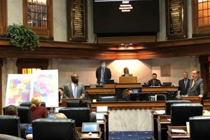
The state Senate and House approved the maps last week. The maps are seen as likely to maintain Republican supermajority control of both houses of the Indiana General Assembly and the 7-2 split of congressional districts. Republicans hold seven congressional seats, and Democrats hold two – the one in Indianapolis and one in the northwest corner of the state.
Three House Republicans voted against approving the maps: Reps. John Jacob, R-Indianapolis; Matt Hostettler, R-Patoka; and Jeff Ellington, R-Bloomington. One Republican senator voted against the new maps: Sen. Ron Grooms, R- Jeffersonville, who is retiring.
The maps contain districts that are more compact, and map-drawers appear to have followed the ideas laid out before the 2011 redistricting process by then Secretary of State Todd Rokita, including that districts should be compact in size, respect county lines when possible and maintain “communities of interest.”
The new House map increases the number of counties that are entirely in one House district from 26 to 32. Each House district contains close to 67,855 people. The new Senate map increases the number of whole counties in districts from 49 to 65.
The new congressional map keeps 84 of the state’s 92 counties whole. The biggest change was the 5th Congressional District, now represented by Republican U.S. Rep. Victoria Spartz. It dropped the northern piece of Marion County and the eastern part of Boone County and now encompasses almost all of Howard County and all of rural Delaware County.
The two southeast Indiana congressional districts were reconfigured with the ninth district, represented by Republican Rep. Trey Hollingsworth, now stretching across the bottom southeast of the state, and the fourth district, represented by Rep. Greg Pence, running on top of it and taking in the bottom third of Marion County, adding an urban area to the otherwise rural-focused district.
Each congressional district contains close to 753,948 people.
In a Senate elections committee hearing last week, Sen. J.D. Ford, D-Indianapolis, echoed the complaints of Democrats at public hearings that the new Senate map appeared to break up three cities – Fort Wayne, Lafayette and Evansville – in order to dilute the influence of Democrats.
Disclaimer: This content is distributed by The Center Square